GIS Analyst & Geomorphological Mapper
I specialize in developing high-accuracy geomorphological terrain models, publication-quality spatial datasets, and automated web-GIS platforms tailored for the mining, resource, and geotechnical sectors. Co-author of an upcoming volume on Metro Vancouver geology and recipient of the 2026 Esri Canada GIS Scholarship.
AVAILABLE
LAT: 49.28° N|LON: 123.12° W
>ArcGIS Pro · QGIS · Terrain Analysis · Geomorphology · Python · Next.js
Open to GIS Technician, Junior GIS Analyst & Mining/Resource-Sector GIS roles across BC and Canada
Portfolio
Key Projects
Terrain analysis, geomorphological mapping, automated GIS pipelines, and resource-sector spatial workflows.
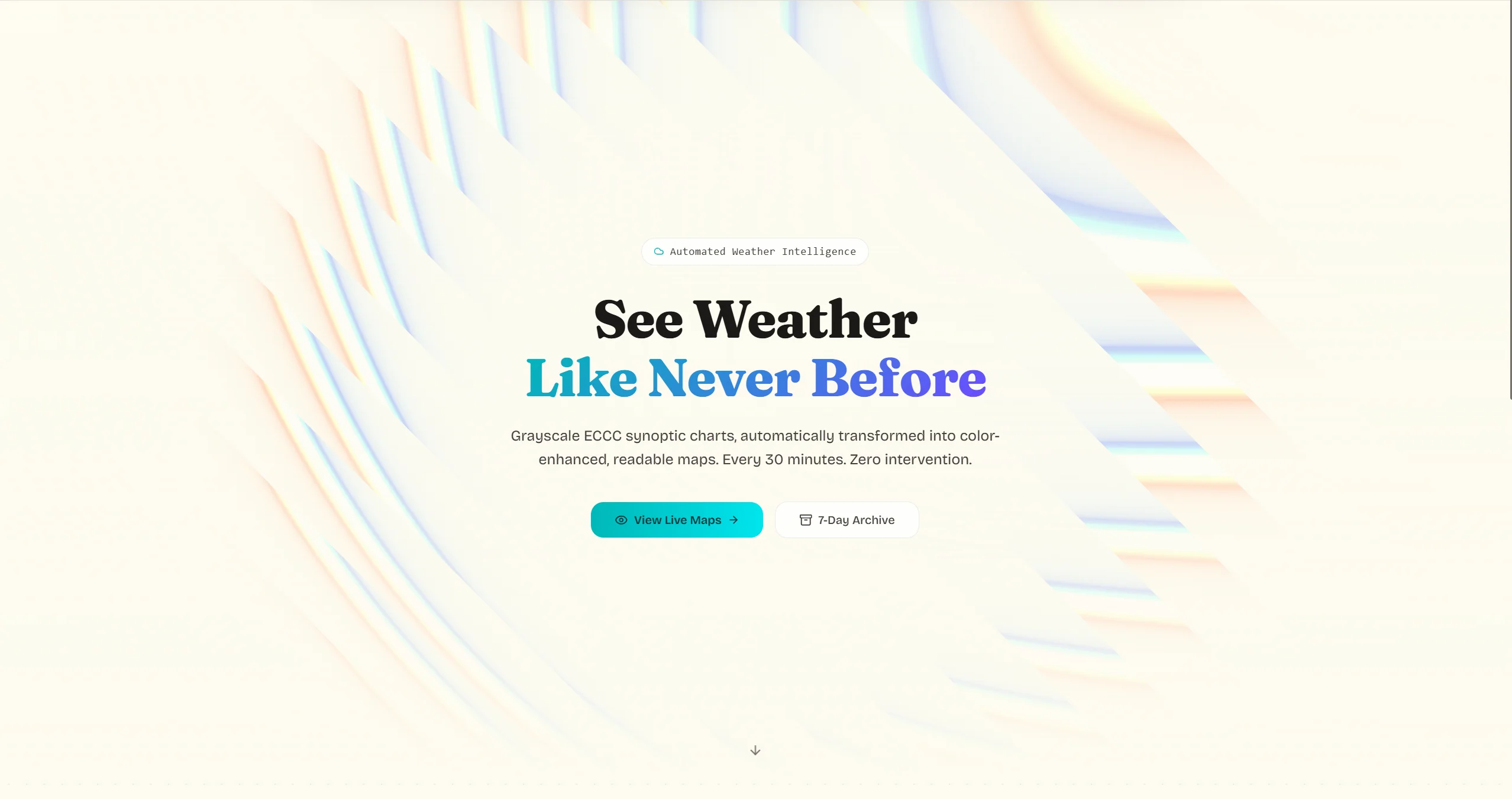
AtmoLens
Fully automated geospatial pipeline fetching ECCC synoptic weather charts every 30 minutes, applying GLSL-based colourisation to grayscale outputs, and archiving a 7-day rolling catalog on Vercel — demonstrating serverless geospatial automation, cloud architecture, and environmental data monitoring skills directly applicable to mine-site weather operations.
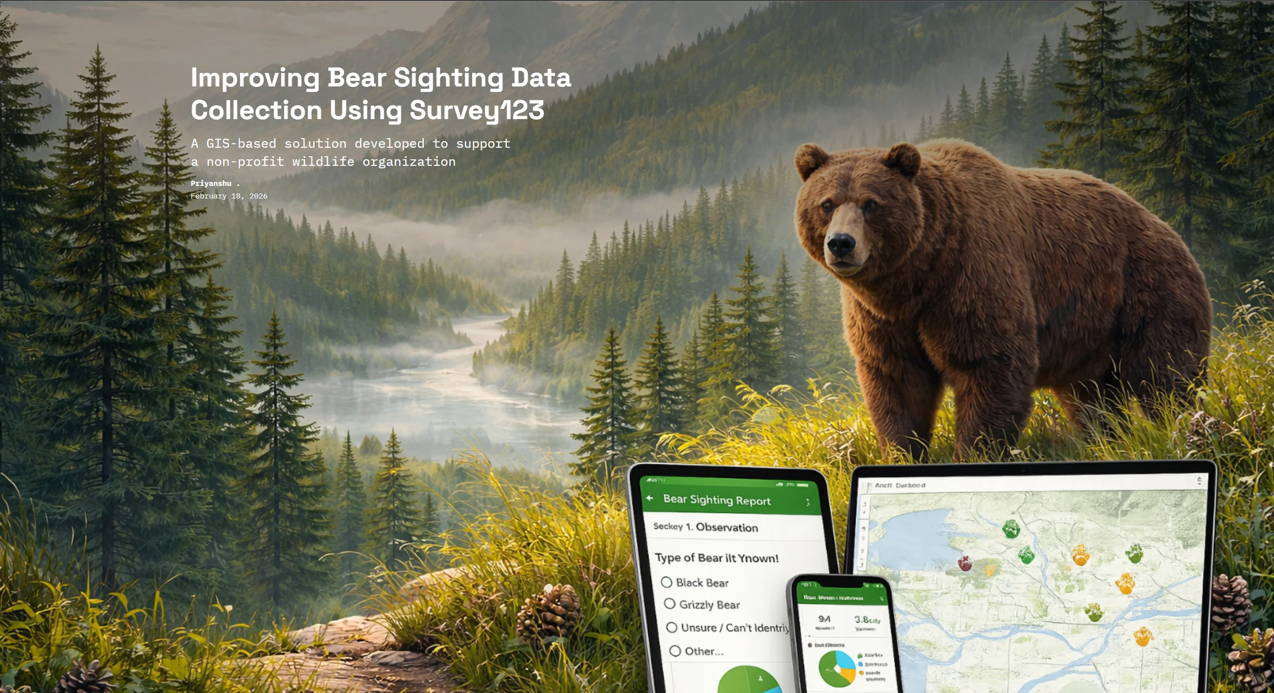
Bear Sighting GIS
Survey123-powered field data collection workflow with auto-stored spatial records in ArcGIS Online, feeding a real-time web map with pie charts and summary indicators — demonstrating the exact field data → spatial database → live dashboard pipeline used for mine-site incident logging, environmental observation reporting, and field crew safety tracking.

Priyanshu
Junior GIS Analyst · Geospatial Research Assistant
// about.me
Hello, I'm Priyanshu
I am a detail-oriented GIS Analyst, Geospatial Researcher, and academic co-author based in Metro Vancouver. I currently produce publication-quality maps and spatial visualizations for faculty-led geology research at Capilano University.
From complex overlay analysis to configuring survey-driven web platforms, I specialize in transforming raw geographic data into clear, decision-ready outputs. I adhere to rigorous QA/QC standards to ensure cartographic precision and data integrity.
My geomorphological background — including terrain analysis, landform interpretation, and DEM-derived mapping — positions me for mining, geotechnical, and resource-sector GIS roles where accurate site characterisation drives critical decisions. I am actively targeting GIS Technician and Junior Analyst positions at firms including Stantec, SLR Consulting, Geosyntec, and the BC Geological Survey.
ORCID: orcid.org/0009-0008-7268-8779
What I Work On
Core GIS Focus Areas
Spatial Analysis
Geoprocessing, overlay analysis, and scenario-based geographic problem-solving.
Cartography
Publication-quality map production with clear legends, scales, and projections.
Data Integration
Sourcing, cleaning, and integrating multi-format spatial datasets with systematic QA/QC.
Web GIS
Survey123 forms, ArcGIS Online dashboards, and dynamic web-based mapping systems.
Research Support
Faculty-led academic research with spatial visualization and geographic data documentation.
Decision Support
Turning complex geographic data into clear, decision-ready maps and spatial outputs.
Geomorphology
Terrain analysis, landform mapping, and DEM-derived datasets for geomorphological characterisation and site assessment.
Mining & Resource GIS
Spatial data workflows supporting mine-site monitoring, terrain suitability, environmental compliance, and resource exploration.
Technical Capability
Tools & Skills
GIS Platforms
Spatial Analysis
Cartography
Data Management
Web GIS
Terrain & Geomorphology
Mining & Resource GIS
Supporting Tools
Mapping My GIS Journey
From my first basemaps to WebGL experiments and spatial storytelling.
Nov 2025 — Present
Nov 2025 — Present
Geospatial Research Assistant & Terrain Analyst
Applying geomorphological principles to DEM-derived terrain datasets (slope, aspect, hillshade, landform classification) to support faculty-led geology research and resource-sector mapping workflows.
- •Producing publication-quality maps, figures, and spatial visualizations for a faculty-led academic book on Metro Vancouver geology.
- •Sourcing and integrating geospatial datasets from the Geological Survey of Canada, BC government, and TransLink GTFS feeds.
- •Designing multi-scale cartographic products including geological maps, field trip route maps, and study area location maps.
- •Performing data cleaning, attribute management, and QA/QC to ensure accuracy across all spatial deliverables.
May 2025 — Dec 2025
May 2025 — Dec 2025
GIS Analyst — Applied GIS Projects & Spatial Analysis
- •Designed and analyzed spatial datasets using QGIS and ArcGIS Pro, managing vector/raster data, projections, and attribute tables across multiple applied projects.
- •Performed spatial analysis and geoprocessing, including overlay analysis, buffering, spatial queries, classification, and thematic mapping.
- •Produced professional, publication-ready maps using cartographic best practices to support geographic analysis and decision-making.
- •Built a survey-driven, auto-updating GIS wildlife reporting system linking Survey123 data collection to dynamic ArcGIS Online visualization.
May 2024 — Apr 2026
May 2024 — Apr 2026
Capilano University
Associate of Science (North Vancouver, BC)
Recognition
Honors & Awards
2026 Esri Canada GIS Scholarship
Issued by Esri Canada · 2026
A nationally competitive award recognizing academic excellence and demonstrated skill in geospatial technologies. The scholarship supports ongoing contributions to the GIS field through software provision, funding, and professional development.